Having visited Goodwood, Ontario to see three major exterior locations for the comedy
Schitt’s Creek, our “fandom tour” would not be complete without seeking out the site used to represent the
Rosebud Motel, which was located near Mono, Ontario. Pairing this with a hike through
Mono Cliffs Provincial Park with a stop on the way home at the
Hockley General Store in Hockley Valley, we had the makings of another fun, single-day road trip. As always happens on our driving adventures, we usually stumble upon unexpected stops along the way. On this trip, we spotted a cool
antique shop in the middle of nowhere while driving along Mono Centre Road/Dufferin County Road 8, and stopped in the small community of
Beeton, Ontario to get a closer look at the interesting architecture found there.
The
Rosebud Motel that Johnny, Moira, David and Alexis Rose reluctantly moved into, in the fictitious town of
Schitt’s Creek, is actually the
Hockley Motel found on Hockley Road just east of Mono, Ontario. After the end of the series in 2020, the sign from the show is gone and the motel is actually up for sale. A long metal chain blocks the entrance to the driveway to prevent cars from approaching, and a “Beware of Dog” sign attempts to keep foot traffic away. It will be interesting to see what happens to this motel and whether whoever buys it will try to cash in on its former claim to fame.
Mono Cliffs Provincial Park spans 1810 acres and is located just north of the township of Mono. It is part of both the Bruce Trail and the Niagara Escarpment. There are multiple loop trails to choose from, giving you varied terrain including cliff faces, interesting rock formations, vast expanses of forests, and several lakes and ponds. You can buy a half day or full day pass to visit the park, although it was unclear if anyone is actually checking during the pandemic. We bought a full-day pass and arrived early, hoping to spend a good part of the day here. Unfortunately it started to rain just before noon, so we cut out some of the loops that we were hoping to explore and will need to come back another day. We ended up traversing sections of the Carriage Trail, Spillway Trail, Cliff-Top Side Trail and Walter Tolver Trail. On our next visit, we would like to check out McCarston’s Lake Trail, the Lookout Trail and the South Outlier Trail.

We probably missed the height of the fall colours by a week or so, since many of the leaves had already fallen, creating an orange and gold blanket under the trees. The views were quite varied but all beautiful as we hiked from trail to trail. We love how peaceful and serene it is to visit conservation areas mid-week when we are often the only people on the trails, especially when we get an early start. Walking on the Carriage and Spillway Trails, we passed by several bodies of water as well different types of trees and a variety of foliage.
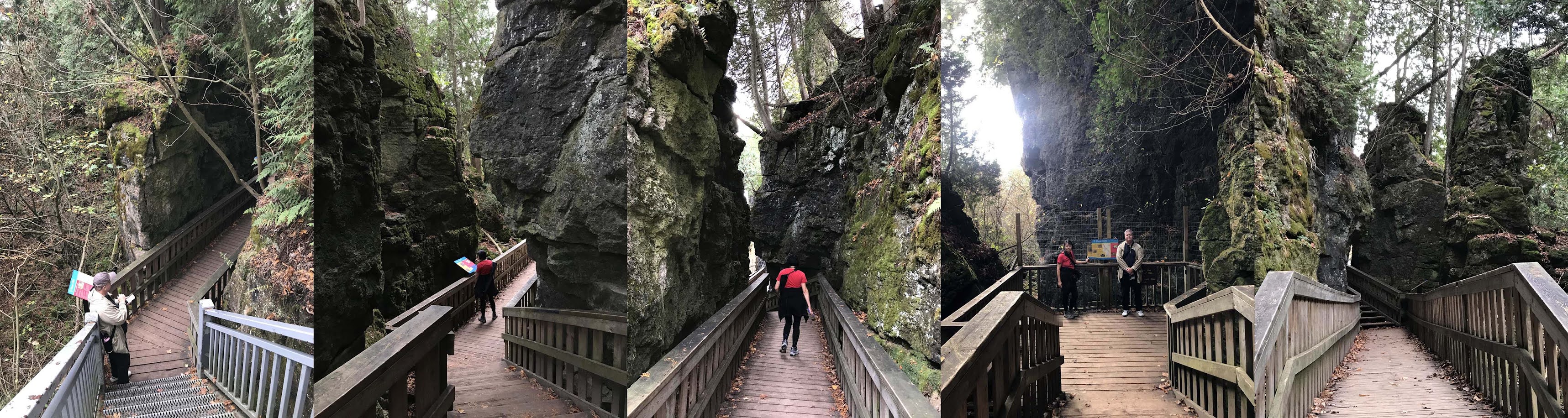
As we were nearing the viewing platform at the top of the
Cliff-Top Side Trail, we were on the lookout for a set of stairs which, based on our research, would lead down to an area often referred to as “
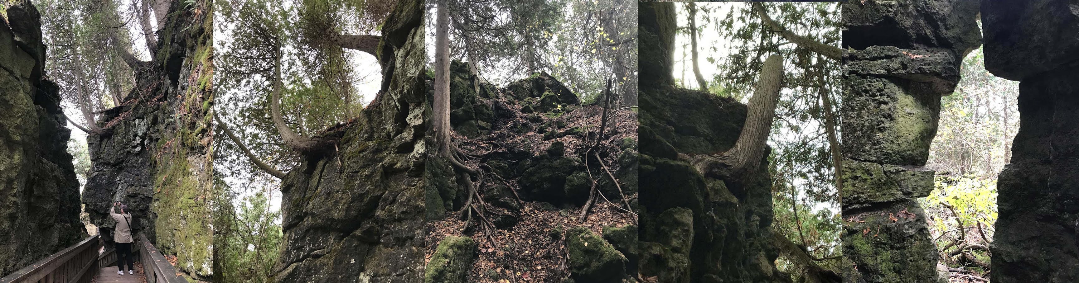
Jacob’s Ladder”. After descending the steep metal stairs, you come to a cavernous pathway cut through a canyon with looming 30m high cliffs on both sides. The jaunt along a wooden boardwalk was short, but the experience was eerie and magical.
Some of the rock formations were covered with moss and others have cedar trees growing out of the stone surfaces. Many of the small, gnarly cedars growing out of the cracks and crevices of the rocks are hundreds of years old, with the oldest one being over 1500 years old. In some cases you can see the sprawling roots growing on top of the rocks. Occasionally the rock formations come together in such a way that a “window” is formed exposing the woodlands that lie in the distance.
Ascending back up the stairs and continuing on the Clifftop Side Trail, we soon arrived at the
Viewing Platform which gave us a great view of the forest below. Again, it was too bad that we missed the peak of the fall colours, and that the lack of sunshine meant the remaining the hues appeared a bit dull. But the mere expanse of all the trees and the pretty pond below was still breath-taking and we could imagine how stunning the sight would be on a bright day at the height of the autumn leaves season.
As the clouds continued to darken and we experienced an intermittent drizzle of rain, we headed back towards our car, but decided to descend another set of steep stairs in order to walk a portion of
Walter Tovell Trail before calling it quits. This led us through a beautiful forest of tall, thin, tightly planted birch and fern(?) trees. Walking along the base of the park allowed us to look back up on the eponymous “
Mono Cliffs”. We could see white rock faces streaked by a scaly covering of yellow lichen. When we reached a clearing, we looked up in the sky and saw a flock of four to six hawks swooping around. We reached the parking lot just after noon, and just as it started to rain much harder. While the lot was relatively empty with only a couple of cars when we arrived in the morning, it was now packed. I felt sorry for the people unloading their bicycles who had bought the half day pass for the second part of the day, and now it was raining. I guess the hard-core mountain bikers won’t care.
Upon leaving Mono Cliffs Provincial Park, we headed south along the relatively isolated Mono Centre Road towards Hockley. Suddenly out of the blue, I spotted a sign advertising antiques, lemonade, pumpkin muffins and short bread. Built on the property of a rural home,
Antiques and Other Stuff is a cute little antique shop that features a floor-to-ceiling stained glass window and a wrought-iron spiral staircase. Speaking to the owner, we found out that she and her husband purchased the window from a Catholic Church in Brooklyn and it was so large that they needed to build a new structure to house it! The shop is full of knickknacks and antiques for sale, and the grounds have cute garden signs and sculptures which are also for sale. In addition to picking up a couple of muffins and cookies, we bought a pretty faux-vintage mismatched blue tea cup and saucer to add to our collection at home. It was cash only and we only had limited cash with us, or I would have taken a closer look at the garden sculptures.
Continuing along the roads to
Hockley, we drove some scenic and quite exhilarating stretches of steep and windy roads that felt like a twisty roller coaster. At one point we passed by the entrance to the Hockley Valley
Glen Cross Side Trail, which has another 4km of hiking trails through the woods and is part of the Bruce Trail. We made note of this as somewhere we could explore in the future.
Reaching our destination of the
Hockley General Store, we were hoping to have some lunch before heading home. Serving the Hockley Valley Area, this is an all-encompassing store offering fresh, local and organic produce and other groceries, packaged goods, LCBO & Beer outlet, coffee shop, bakery, frozen prepared meals, as well as a food counter where you could order breakfast or lunch meals. The General Store has a rustic feel, guarded in front by the “Hockley Horse”, the store mascot which is painted with scenes of equestrians on one side and the Canadian Flag on the other. Scattered around the storefront are pumpkins and some squashes of such weird shapes that they looked like works of art.
Inside, we admired the surprisingly good selection of alcohol as well as what would be considered “fine foods” with brands that you would find in higher-end grocery stores. For lunch, I ordered a roast beef panini with caramelized onions, swiss cheese and house-made horseradish mayo, while Rich got the Hockley Hero sandwich—a grilled baguette with ham, turkey, Italian sausage, cheddar, swiss cheese and house-made mustard. We shared a butter tart and a Bull's Head ginger beer, a brand that we were not familiar with but was quite good.
Across from Hockley General Store is a pretty house with a large wrap-around front porch and elements of the Carpenter Gothic style, with the small steeped pitched portion of the roof embellished with a decorative trim and a window underneath. There is a historic plaque in front that indicates this building used to be the
old Post Office from 1863-1918 and describes the contributions of
Thomas Hockley, who the area was named for. The house next door has a quirky sculpture of cowboy riding a horse rodeo-style.
On the way home from Hockley Valley, we drove through the town of
Beeton, Ontario. We were impressed with the cool architecture that we saw there, so we decided to stop and look around. We learned that the town was renamed from Clarksville to Beeton, in honour of
David Allanson Jones, a renowned local apiarist who raised bees, ran the company Jones Perfection Bee Hive, was editor for the Canadian edition of “The Bee Journal” and was postmaster for the town. The tomb for D.A.Jones was the largest in St. Andrews Presbyterian Cemetery, whose land he donated. The local public library is also named the D.A.Jones Branch. The historic building currently housing the IDA Pharmacy and Bee Town Medical Centre dates back to 1894 and was once a printing press.
We liked the unique circular shape of the
St. Andrews Presbyterian Church, which is directly across the street from the cemetery, also on land donated by D.A. Jones. Built in 1890 on a foundation of stones, the church has 40-foot ceilings, a sloping floor and was originally heated with a wood stove in the basement where services were held in the winter so that the congregation could keep warm. At 148 Main Street West, just a couple of buildings west of St. Andrews Church, there seems to be yet another church, but on closer look, it became apparent that this gorgeous church-like building with large stained glass windows and a tower, is actually a private home with a pool in the backyard. I could not find reference to whether this ever used to be a church, but it certainly looks like one. There were many other beautiful homes on Main Street and I would love to return some day to take a closer look at them.
Quaint shops and eateries can be
found further east on the historic Main Street.
There is the Lickity Split ice cream parlour with 24 flavours of soft ice cream
(unfortunately closed for the season), and couple of “punny” establishments
including the massage therapy centre called "Nice to be Kneaded”, and the “Bee Sew Busy”
gift and crafts shop. In another bee
reference, the local antique shop is called “The Village Bee”. Across the road can be found the Muddy Water
Hotel Restaurant and Bar, serving beer and chicken wings, burgers and other
fare, with live music acts or a DJ playing music, a dance floor, big screen TV, pool tables and two
patios. Despite the name, there is no indication of this being a hotel. But the building dates
back to circa 1885 and there is a sign advertising “Miss Edgar’s Muddy Water
Hotel and Home for Wayward Girls”. I’m
not sure what this refers to as the only mention of this that I could find on the internet was a country
song by Harlan Wells called “Miss Edgar’s Muddy Water
Tavern” which includes "wayward girls" in its lyrics. It is not clear whether this building inspired the song or the song inspired the sign on the building?